This summer, I’ll go to Croatia. For once, a normal journey. Everyone will be there. And to think that I’ve gone halfway round the world but I’ve never been there.
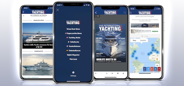
I’ve never been there and, now, I want to plan my journey as best as possible; so, I’ll study my legs on the online pilot book of The International Yachting Media.
The page opens on the map of the Northern Mediterranean, where blue circlets delimit different zones while numbers indicate the ports and anchorages within that area.
These are Google maps; therefore, you can zoom in and out and switch from the map view to the satellite mode.
Select a geographical area
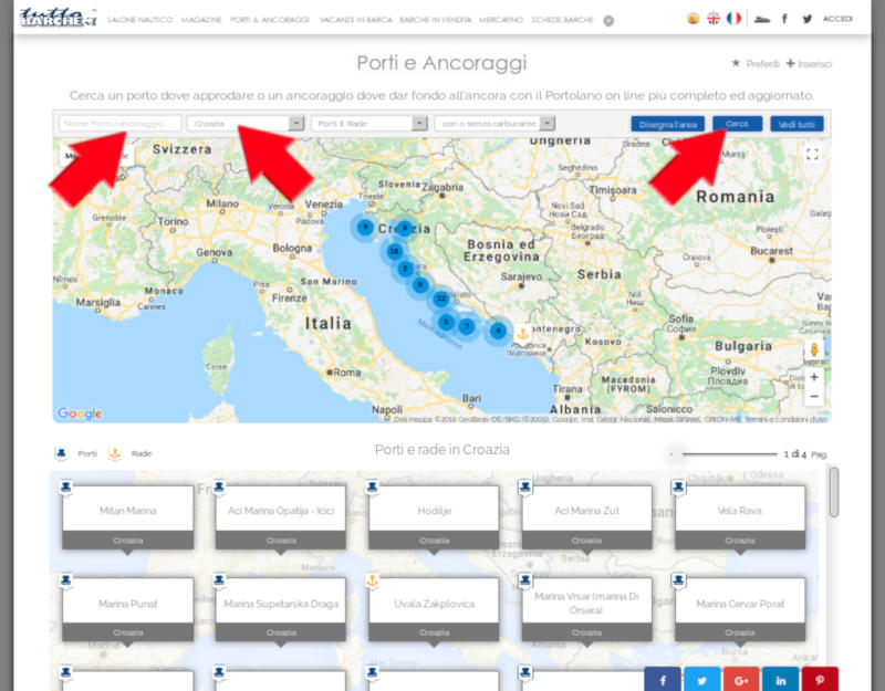
At the top of the page, there’s a search box where you can enter the location to search for and/or select a geographical area ( I’m immediately distracted: Trentino Alto Adige…are there any ports in the Italian Dolomites? Ah, well, there are lakes, too: Torbole, Riva del Garda.. ah, what memories! And what wind, what experiences!).
You can also select only the ports and anchorages search and look for the marinas equipped with filling station: that’s very useful!
Distracted by my memories, I make my first mistake since I write “Croatia” in the ” Port/Anchorage’s Name” field. They’re true, it is written: I have to fill the ” Port/Anchorage’s Name” field with the name of the marina and not with a geographical area or a city.
So, I select “Croatia” from the Geographical Area menu, I click on the Search button and the page shows me a map with many blue circlets positioned along the Croatian coasts, with a list of all the marinas and anchorages below.
Draw your geographical area
But wait, wait, please.
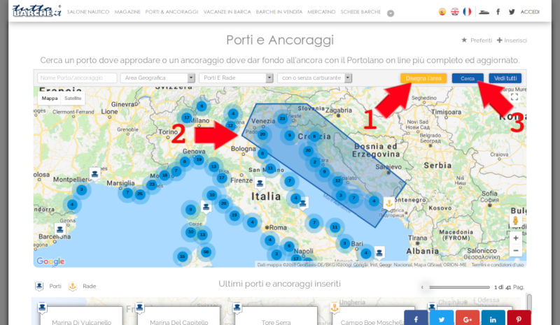
I’ve seen a thing that is perfect for me. Next to the Search button, there’s another one: “Draw the area“.
In this moment, I certainly need it. Since I’m leaving from Venice and I haven’t a precise itinerary yet, perhaps I might stop in Veneto, Friuli, Venezia Giulia or Slovenia.
So, I come back, I click on the “Ports and Anchorages” label in the menu at the top, I click on the “Draw the area” button and I position myself on the map: clicking (or touching, if you have a touchscreen display) on the angles of an imaginary polygon, I select a window on the Northern Adriatic. After selecting the area, I click on the Search button: blue circlets are in the polygon and, at the bottom of the page, I find a list with all the ports and anchorages available in that area.
Choose ports
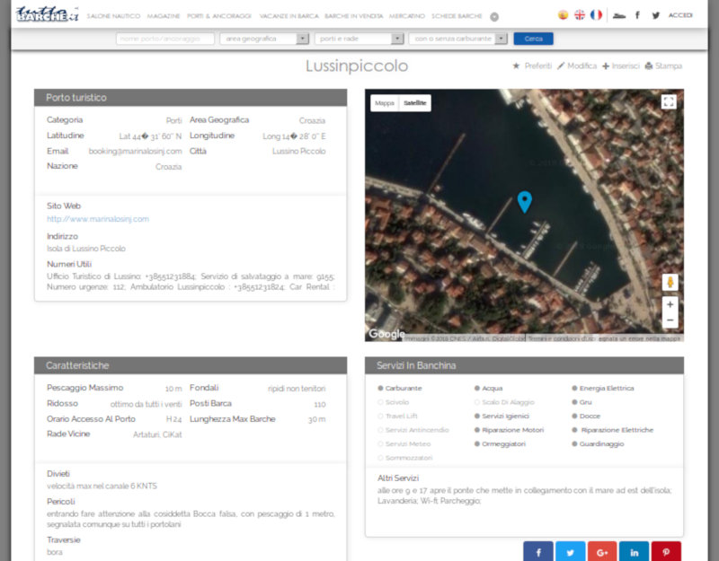
I start to examine the ports I might find along my way.
For example, the port of Lussinpiccolo. By clicking on the bollard icon, I see a frame showing the name of the port. By clicking on it, a file opens.
The marine file contains all the data useful to identify it, from coordinates to telephone numbers, from postal addresses to websites. It also contains the physical characteristics of the port ( sea bottom, minimum and maximum draft, and so on), opening times and services: from mooring attendants or scuba divers to the possibility to fix failures or refuel.
The file is completed by a description of the marina and a map with satellite pictures.
If you want to book a berth by smartphone,you only have to touch the phone number, call the facility and ask for more details.
If you don’t like the marina or you simply want to go elsewhere, a list shows all the anchorages available in the surroundings.
Save Favourites
If you like
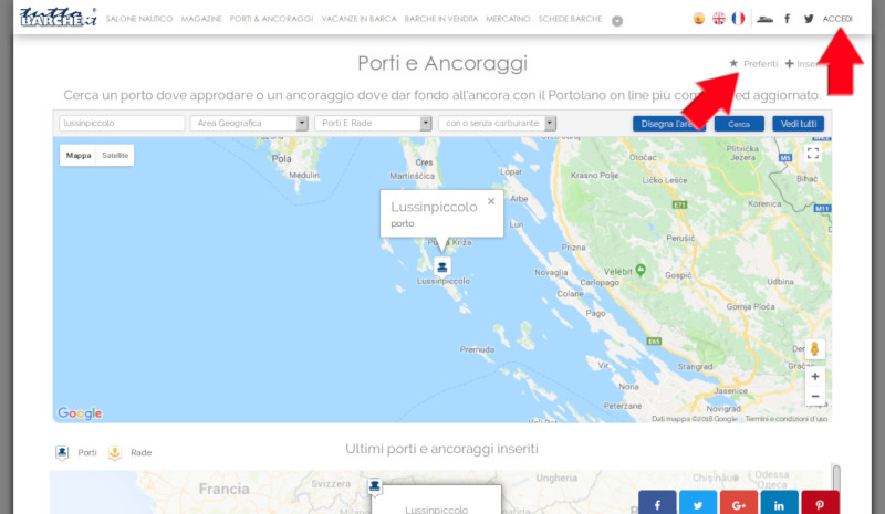
a port and you want to include it in your itinerary, you can save it in your favourites folder.
You only have to click on the star on the top right and the file of the port will be added to your personal list.
While I’m at it, I examine the anchorage on the island of Unije, just a few miles away. In addition to the map and the satellite picture, the file also informs me about the maximum and minimum draft, the quality of shelter and sea bottom and indicates other anchorages in the surroundings. In the “Dangers” field, I read ” Very crowded bay, pay close attention to anchoring maneuvers”. Human danger: always the most feared one.
I save the ports and anchorages I’m interested in so that I can find them easily later. I only need to enter my personal area and select ” My Favourites”.
Since we can’t be too careful and phone reception is not always good ( my phones often fall overboard), I print the files of the ports and anchorages I’m interested in and I put them in a convenient folder. If you prefer, you can also save your files in pdf format on your tablet or smartphone.
Add and Update
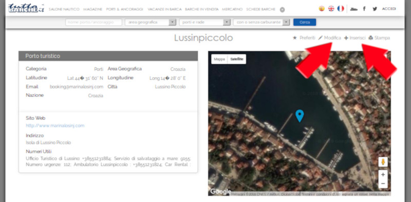
Now it’s time to set sail, with our pilot book in our hands. I promise I’ll tell you my experience.
I’ll take it further: I’ll complete the pilot book with my additions, recommendations and corrections.
I only need to click on the Update or the Add button.
Bluff is not allowed, because the staff of Boatandboats will control everything 😉

